Ancient glass vessels restored after Beirut blast go on display at British Museum

Eight objects from Roman, Byzantine and Islamic periods were shattered in port explosion two years ago

A team of experts reassembled hundreds of pieces of glass. Photograph: The Trustees of the British Museum the American University of Beirut/PA

Restored ancient glass vessels that were damaged in the Beirut port explosion two years ago have gone on display at the British Museum.

The eight objects, from the Roman, Byzantine and Islamic periods, have been pieced back together by museum conservation experts and are being showcased at the London venue until October before being returned to Lebanon.

The artefacts are among the precious items to have been saved in an emergency recovery campaign that was launched after the American University in Beirut (AUB) Museum was heavily damaged in the disaster that killed at least 218 people, wounded 7,000 and displaced 300,000 people in August 2020.

The vessels were among 74 items from the Roman, Byzantine and Islamic periods in a case at the AUB that fell over after being hit by the shockwave of the explosion, which occurred 2 miles (3km) away after a massive stockpile of ammonium nitrate exploded.

The blast hit the building and smashed the glass objects inside the case.
The British Museum’s director, Hartwig Fischer, said the items – which are on show in an event called Shattered glass Of Beirut at the Asahi Shimbun Displays – “tells a story of near destruction and recovery, of resilience and collaboration”.

Hidde van Seggelen, president of the European Fine Art Foundation (Tefaf), said: “We are immensely gratified to see the restoration of these ancient glass objects come to fruition.”

“Bringing these pieces back to their rightful form has been a compelling symbol of resilience and we are honoured to have been part of this important collaboration,” he added.

A team of experts carefully reassembled hundreds of fragments of glass and the vessels have been repaired so they are structurally sound, although the breakage marks can still be seen.

Dr Nadine Panayot, curator of the AUB Archaeological Museum, said: “Reconstructing these fragmented glass vessels one tiny bit at a time, helped to reunite, to recognise their heritage value, and to build a sense of community.

“To see these shattered and delicate vessels reassembled not only sparked a healing process, but also inspired me to hope for a better future.”

The British Museum said the vessels that have been conserved at the London site are hugely important in telling the story of the development of glass-blowing technology in Lebanon in the first century BC, a period in which glass production was revolutionised.

Last month, the deputy director of the British Museum proposed a Parthenon partnership with Greece that could see the marbles returned to Athens after more than 200 years.

The sculptures – 17 figures and part of a frieze that decorated the 2,500-year-old Parthenon temple on the Acropolis – were taken by Lord Elgin in the early 19th century when he was the British ambassador to the Ottoman empire, and have since been the subject of a long-running dispute over where they should be displayed.

In an interview with the Sunday Times Culture magazine, Jonathan Williams said the British Museum wanted to “change the temperature of the debate” around the marbles.

Williams said: “What we are calling for is an active ‘Parthenon partnership’ with our friends and colleagues in Greece. I firmly believe there is space for a really dynamic and positive conversation within which new ways of working together can be found.”

Source: https://www.theguardian.com/culture/2022/a...

Ancient Coin Discovery With An Astronomical Mystery

What does the ancient coin found recently off the shores of Israel depict?

You never know what discoveries are waiting to be found in old records or artwork. A recent archaeological find sent us down just such an astronomical rabbit-hole, leading us to ideas that are fun and interesting to consider.

It all started with the recent amazing discovery of the ancient Roman coin off the coast of Haifa, Israel in the Mediterranean Sea. The bronze coin depicts the zodiac sign of Cancer, along with the Moon goddess Selene and crescent Moon. The ancient coin would have been part of a set of twelve, depicting the houses of the zodiac. The coin was recovered by the Israel Antiquities Authority’s Maritime Archaeology Unit.

“This is the first time such a coin has been discovered off Israel’s coast,” says Director of the Maritime Archaeology Unit Jacob Sharvit in a recent press release. “It (the coin) is a rare addition to the National Treasures collection.”

The ancient coin was found as part of a horde from a presumed ancient shipwreck. From the inscription on the obverse, researchers know that the coin was minted in Alexandria, Egypt during year eight of the reign of Roman emperor Antonius Pius, which would translate to 144-145 AD.

Now, I noticed something intriguing on the image, and did some brief research.

The ancient coin also shows a bright ‘star’ near the Moon. I began to wonder if this depicted a real astronomical event, visible from the Mediterranean region in the years before the coin was minted. Now, no bright star exists in Cancer; I therefore suspected it was actually a bright planet, say, Jupiter or Venus. I did a search using the Occult 4.2 program and the planetarium program Stellarium (which takes in to account the ~26,000 year precession of the equinoxes and stellar proper motion over the centuries), and found one event that was especially intriguing: the dusk conjunction of the waxing crescent Moon and Jupiter on the evening of June 4th 140 CE… in the sign of Cancer.

Dusk looking west from the Mediterranean region on the evening of June 4th, 140 AD. Credit: Stellarium

Not only did this occur in the reign of Antoninus Pius, but it would have been visible right before the death of his beloved wife Faustina the Elder in late 140 AD… perhaps the ancient coin commemorates her passing? Certainly there’s record of Pius’s devotion to Faustina, and his subsequent campaign to deify Faustina after her death.

The Moon occults Jupiter on June 4th, 140 CE. Credit: Occult 4.2.

Of course, the modern science of astronomy has its hoary roots in the archaic practice of astrology. Ancients watched the sky, noted what they saw and assigned import to them versus human and terrestrial affairs. We all remember the astrologer’s admonition to Julius Caesar to ‘beware the Ides of March,’ and astronomical historians from Kepler and Newton onward have gone broke trying to link the ‘star’ that guided astrologers to Bethlehem with a true astronomical phenomenon.

Under one possible scenario, a court astrologer could have assigned significance to the conjunction of Jupiter with the Moon in Cancer, a portent that later moved a grieving Pius to commemorate the death of his wife, casting her as the Moon goddess Selene.

The base of the column of Antoninus Pius in Rome, depicting Pius and Faustina. Credit: Saiko/Wikimedia Commons 3.0 license.

I ran this idea past fellow amateur astronomer John Flannery, and he had some interesting ideas. He noted that while it’s tempting to assert that the dots on the shell of the Crab depict the open cluster Praesepe (Messier 44), Steve O’Meara also notes in a past Sky & Telescope column that individual stars in the cluster would be hard to discern with the naked eye.

Flannery also pointed me toward another interesting possibility for the mystery star: the 141 CE apparition of Halley’s comet. I ran a simulation using data from NASA/JPL/Horizons, and 1P/Halley would have been at Right Ascension 9 hours, 13’ 12’, Declination +24º 10’ on April 28th, 141 CE in the adjacent constellation of Leo the Lion shinning at +1st magnitude while the Moon was in Cancer at dusk.

Halley’s Comet in late April, 141 C.E. Credit: Stellarium.

“In astrology, the Moon rules the sign of Cancer,” says Flannery. “Regardless of what the coins depict, I think it is an extraordinarily beautiful set (referring to the twelve coin zodiac set) and shows delicate workmanship.”

We may never know for sure. What could prove or refute the assertion is the discovery of earlier (pre-second century) coins, with the same Moon-star Moon goddess inscription.

Beyond just being a fun astronomical mystery, such depictions of astronomical events in art, text or ancient coins are important in pinpointing dates and events in the past. For example, one recent ancient Chinese text may have chronicled the earliest depiction of aurora, and another text may note a sunset annular eclipse alluded to in the Book of Joshua.

In any event, this is all speculative, but it’s fun to consider. In regards to astrology, Shakespeare said it best: “The fault… is not in our stars, but in ourselves.”

Dawn looking east on the morning of September 8th, 2026. Credit: Stellarium.

In the meantime, you can enjoy another such tryst of the crescent Moon, Jupiter in Cancer at dawn on the morning of September 8th, 2026, followed by a fine occultation of the king of the planets for North America on the next lunar cycle on October 6th, 2026. Be sure to watch if skies are clear as the celestial drama unfolds in the dawn, and wonder just what folks might have seen in the sky, nearly two millennia ago.

Occultation path for the October 6th, 2026 event. Credit: Occult 4.2.

Lead image credit: Roman coin recently discovered off of the coast of Haifa, Israel. Credit: Danfa Gazit/Israel Antiquities Authority.

Source: https://www.universetoday.com/157170/ancie...

2,200-year-old Roman fountain unearthed in northwestern Turkey

Excavations in ancient city of Assos continue uninterrupted for 42 years, says head of excavations

CANAKKALE, Turkey

The remains of a 2,200-year-old Roman fountain have been uncovered in northwestern Turkey, archeologists at the ancient site of Assos said on Monday.

"According to our initial findings, we learned that it was a magnificent fountain structure. We know of many cisterns in Assos, but this is the first time we've come across a monumental fountain structure," dig site head Nurettin Arslan told Anadolu Agency.

"It's a very important structure in terms of urban architecture," said Aslan, who is also a professor at the Onsekiz Mart University in Canakkale province, where the ruins are located.

Underlining that the excavations at Assos have continued uninterrupted for 42 years, he said the current 30-strong team, including scientists and academics from Germany, were planning this season to unearth multiple cisterns added onto the ancient city's gymnasium.

The fountain they discovered was in front of these Roman-era cisterns, explained the archeologist, adding that it had been seriously damaged during the Byzantine period.

"Despite this, once the initial excavation is complete, we can re-erect the existing pieces and allow visitors to grasp the scene or appearance in front of the fountain a little better," he said.

Assos, also known as Behramkale, was one of the most important port cities of its era and is a crucial cultural heritage site dating back from the period of Roman rule in the region. It includes an ancient theater, agora, necropolis, and protective walls.

Located 17 kilometers (about 11 miles) south of the present-day town of Ayvacik, it was added to UNESCO's Tentative World Heritage List on April 15, 2017.

According to UNESCO, Assos was also a major Greek city-state, and maintained its regional importance until the Byzantine Empire.

Turkish archaeologists started excavations at Assos in 1981.

Source: https://www.aa.com.tr/en/culture/2-200-yea...

New Pompeii Find Is a Middle-Class House Trying to Look Rich

The eruption of Mount Vesuvius in the year 79 wiped out the city of Pompeii. Even though it’s a bustling tourist site, scientists regularly unearth interesting archeological finds. The most recent includes remarkably well-preserved household items. According to the Archaeological Park of Pompeii’s news release, what’s particularly interesting is their relative simplicity compared to the opulence of the attached courtyard. These finds give a look at Pompeii’s middle-class households.

The property is dubbed the House of the Lararium, which is an altar celebrating the household’s guardian spirits. In this case, that’s good luck and prosperity. The lararium itself suggests a rich occupant. But inside the house, the team found only simple wooden furniture and no paintings. This suggests the middle-class family was keeping up appearances rather than living luxuriously.  

“In the Roman Empire there was a significant proportion of the population which fought for their social status,” explains Massimo Osanna, director general of museums, in the release. “It was a social class that was vulnerable during political crises and famines, but also ambitious to climb the social ladder. In the House of the Lararium at Pompeii, the owner was able to embellish the courtyard with the lararium and the basin for the cistern with exceptional paintings, yet evidently funds were insufficient to decorate the five rooms of the house.”

We saw the news on DesignTAXI. The dig uncovered plates, bowls, and amphorae (long-necked jars) as well as furniture like a wooden cabinet, small table, and chest. Other recent discoveries in and around Pompeii include artifacts belonging to the rich, like a Roman chariot. Or the quarter of very poor slave laborers. Middle-class households are apparently more rare and the House of the Lararium is an interesting and unexpected find.

Archeologists also recently found the remains of a pregnant tortoise in Pompeii. It may not be of cultural significance, but it certainly is very interesting.

Source: https://nerdist.com/article/new-pompeii-di...

The Roman Era Gymnasium Found In Ancient City Of Laodicea

A gymnasium dating back to the Roman period was unearthed at a construction site in Sarayönü district in southwestern Turkish province of Konya.

The facility was discovered when an individual preparing to construct a building on his private land located near the ancient city of Laodicea, contacted the local museum directorate for a construction permit to determine if his estate was located on a protected site.


The facility was discovered when an individual preparing to construct a building on his private land located near the ancient city of Laodicea, contacted the local museum directorate for a construction permit to determine if his estate was located on a protected site.


The facility was discovered when an individual preparing to construct a building on his private land located near the ancient city of Laodicea, contacted the local museum directorate for a construction permit to determine if his estate was located on a protected site.


The facility was discovered when an individual preparing to construct a building on his private land located near the ancient city of Laodicea, contacted the local museum directorate for a construction permit to determine if his estate was located on a protected site.


Sarayönü Mayor Nafiz Solak noted that they are preparing a project for the site's protection and make sure that it is open to visitors after excavations are done.


Sarayönü Mayor Nafiz Solak noted that they are preparing a project for the site's protection and make sure that it is open to visitors after excavations are done.


Laodicea is currently on the tentative list of the UNESCO World Heritage Sites in Turkey.​

Source: https://archaeologynewsnetwork.blogspot.co...

Fresh Pompeii discoveries shed light on the city’s lower classes

While excavations in the ancient Roman city tend to focus on the wealthy upper-class, new discoveries reveal details of life for the not-so-rich-and-famous

By FRANCES D'EMILIO

A woman holds one of archaeological remains of glass plates, ceramic bowls and vases are discovered in a dig near the ancient Roman city of Pompeii, destroyed in 79 AD in volcanic eruption, Italy, 2022. Pompeii Archeological Park/Ministry of Cultural Heritage and Activities and Tourism/Handout via REUTERS

ROME (AP) — A trunk with its lid left open. A wooden dishware closet, its shelves caved in. Three-legged accent tables topped by decorative bowls. These latest discoveries by archaeologists are enriching knowledge about middle-class lives in Pompeii before Mount Vesuvius’ furious eruption buried the ancient Roman city in volcanic debris.

Pompeii’s archaeological park, one of Italy’s top tourist attractions, announced the recent finds on Saturday. Its director, Gabriel Zuchtriegel, said the excavation of rooms in a “domus,” or home, first unearthed in 2018 had revealed precious details about the domestic environment of ordinary citizens of the city, which was destroyed in 79 AD.

Pompeii's archaeological park, one of Italy's top tourist attractions, announced on Saturday that new discoveries include furnishings and household objects in the domus, dubbed the House of the Larario for an area of a home devoted to domestic spirits known as lares. POMPEII ARCHEOLOGICAL SITE / AP

In past decades, excavation largely concentrated on sumptuous, elaborately frescoed villas of Pompeii’s upper-class residents. But archaeology activity in the sprawling site, near modern-day Naples, has increasingly focused on the lives of the middle class as well as of servants and other enslaved people.

“In the Roman empire, there was an ample chunk of the population that struggled with their social status and for whom ‘daily bread’ was anything but a given,” Zuchtriegel said. “A vulnerable class during political crises and food shortages, but also ambitious about climbing the social ladder.”

Decoration of the small table

Parco Archeologico di Pompei

The finds unveiled on Saturday include furnishings and household objects in the domus, which was dubbed the House of the Larario for an area of a home devoted to domestic spirits known as lares. The home unearthed in 2018 has one in the courtyard.

Zuchtriegel noted that while the courtyard also had an exceptionally well-adorned cistern, “evidently, the [financial] resources weren’t enough to decorate the five rooms of the home.” One room had unpainted walls and an earthen floor apparently used for storage.

The latest discoveries in the ancient city of Pompeii, August 6, 2022. (Parco Archeologico di Pompei via AP)

In a bedroom, archeologists found the remains of a bed frame with a trace of fabric from the pillow. The kind of bed is identical to three, cot-like beds unearthed last year in a tiny room in another residence that archaeologists believe doubled as a storeroom and sleeping quarters for a family of enslaved inhabitants of Pompeii.

The bedroom findings announced Saturday also included the remains of a wooden trunk with an open lid. Although the weight of beams and ceiling panels that crashed down in the wake of the volcanic explosion heavily damaged the trunk, among the objects found inside was an oil lamp decorated with a bas-relief depicting the ancient Greek deity Zeus being transformed into an eagle. Nearby was a small, three-legged round table, similar to the accent tables in vogue today.

Archeologists work on the site of a new discovery, August 6, 2022.

(Parco Archeologico di Pompei via AP)

Exposing the storeroom revealed a wooden closet, its backboard still intact but the shelves caved in. Archaeologists believe the closet had at least four panel doors and held cookware and dishes for the nearby kitchen. The excavators found a hinge from the enclosure.

Other objects found in the house include a large fragment of what had been a translucent, rimmed plate in brilliant hues of cobalt blue and emerald, and a well-preserved incense burner, shaped like a cradle.

Source: https://www.timesofisrael.com/fresh-pompei...

Mystery of the Greek Noblewoman Buried in her Gold Jewelry 1,800 years ago

Greek archaeologists have discovered a virtually intact grave of an ancient noblewoman buried with her golden jewelry at a Roman burial monument in the island of Sikinos.

Her name, according to a burial inscription, was Neko — or Νεικώ using the Greek alphabet. The box-shaped grave was found untouched in the vault of the Episkopi monument, a rare burial memorial of the Roman era, which was later turned into a Byzantine church and a monastery. Golden wristbands, rings, a long golden necklace, a female figure carved cameo buckle, glass and metal vases and fragments of the dead woman’s clothes were found in the grave. The well-preserved mausoleum on the tiny island, in the

Cycladic group southeast of Athens, was likely to have been constructed to shelter the grave, archaeologists said.

“We were unexpectedly lucky,” Director of the Ephorate of Antiquities of Cyclades Dimitris Athanassoulis told Reuters on Monday. “This is Neko’s mausoleum.”

“It’s very rare. A monument, one of the Aegean’s most impressive, has got an identity. We now have the person for whom the building was built, we have her remains, her name.”

Despite attacks by grave robbers in ancient times and the building’s various uses through the centuries, Neko’s grave was found intact mainly because it was well hidden in a blind spot between two walls at the basement of the building,

Athanassoulis said. He said that experts thought Neko had links to the island but it was not clear whether she was actually from Sikinos.“We are now trying to find out more about her,” he said. “We are still at the beginning.”

Source: https://www.dailymail.co.uk/sciencetech/ar...

Revolutionary Radar Archaeology: Entire Roman City Revealed Without Any Digging

Archaeologists have revealed an entire Roman city without any digging. Their approach could revolutionize the study of ancient settlements.

A slice of ground-penetrating radar data from Falerii Novi, revealing the outlines of the town’s buildings. Credit: L. Verdonck

For the first time, a team of archaeologists from the Universities of Cambridge and Ghent, has succeeded in mapping a complete Roman city, Falerii Novi in Italy, using advanced ground-penetrating radar (GPR). The technology has allowed them to reveal astonishing details while the city remains deep underground.

The archaeologists have discovered a bath complex, market, temple, a public monument unlike anything seen before, and even the city’s sprawling network of water pipes. By looking at different depths, they can now study how the town evolved over hundreds of years.

The research, published on June 8, 2020, in Antiquity, harnessed recent advances in GPR technology which make it possible to explore larger areas in higher resolution than ever before. This is likely to have major implications for the study of ancient cities because many cannot be excavated either because they are too large, or because they are trapped under modern structures.

Quad towing GPR array, with team member Dr Lieven Verdonck (Ghent University) on the Falerii Novi site. Credit: Frank Vermeulen

GPR works like regular radar, bouncing radio waves off objects and using the ‘echo’ to build up a picture at different depths. By towing their GPR instruments behind a quad bike, the archaeologists surveyed all 30.5 hectares within the city’s walls – Falerii Novi was just under half the size of Pompeii – taking a reading every 12.5cm.

Located 50 km north of Rome and first occupied in 241 BC, Falerii Novi survived into the medieval period (until around AD 700). The team’s GPR data can now start to reveal some of the physical changes experienced by the city in this time. They have already found evidence of stone robbing.

The study also challenges certain assumptions about Roman urban design, showing that Falerii Novi’s layout was less standardized than many other well-studied towns, like Pompeii. The temple, market building, and bath complex discovered by the team are also more architecturally elaborate than would usually be expected in a small city.

In a southern district, just within the city’s walls, GPR revealed a large rectangular building connected to a series of water pipes which lead to the aqueduct. Remarkably, these pipes can be traced across much of Falerii Novi, running beneath its insulae (city blocks), and not just along its streets, as might normally be expected. The team believes that this structure was an open-air natatio or pool, forming part of a substantial public bathing complex.

Even more unexpectedly, near the city’s north gate, the team identified a pair of large structures facing each other within a porticus duplex (a covered passageway with central row of columns). They know of no direct parallel but believe these were part of an impressive public monument, and contributed to an intriguing sacred landscape on the city’s edge.

Corresponding author, Professor Martin Millett from Cambridge’s Faculty of Classics, said:

“The astonishing level of detail which we have achieved at Falerii Novi, and the surprising features that GPR has revealed, suggest that this type of survey could transform the way archaeologists investigate urban sites, as total entities.”

Millett and his colleagues have already used GPR to survey Interamna Lirenas in Italy, and on a lesser scale, Alborough in North Yorkshire, but they now hope to see it deployed on far bigger sites.

“It is exciting and now realistic to imagine GPR being used to survey a major city such as Miletus in Turkey, Nicopolis in Greece or Cyrene in Libya. We still have so much to learn about Roman urban life and this technology should open up unprecedented opportunities for decades to come.” — Martin Millett

The research, published on June 8, 2020, in Antiquity, harnessed recent advances in GPR technology which make it possible to explore larger areas in higher resolution than ever before. This is likely to have major implications for the study of ancient cities because many cannot be excavated either because they are too large, or because they are trapped under modern structures.

The sheer wealth of data produced by such high-resolution mapping does, however, pose significant challenges. Traditional methods of manual data analysis are too time-consuming, requiring around 20 hours to fully document a single hectare. It will be some time before the researchers finish examining Falerii Novi but to speed the process up they are developing new automated techniques.

Reference: “Ground-penetrating radar survey at Falerii Novi: a new approach to the study of Roman cities” by Lieven Verdonck, Alessandro Launaro, Frank Vermeulen and Martin Millett, 9 June 2020, Antiquity.
DOI: 10.15184/aqy.2020.82

'The Intervention of the Sabine Women'; a Significant painting of the 18th Century

The Intervention of the Sabine Women is a 1799 painting by the French painter Jacques-Louis David, showing a legendary episode following the abduction of the Sabine women by the founding generation of Rome.

David began planning the work while he was imprisoned in the Luxembourg Palace in 1795. France was at war with other European nations after a period of civil conflict culminating in the Reign of Terror and the Thermidorian Reaction, during which David had been imprisoned as a supporter of Robespierre. David hesitated between representing either this subject or that of Homer reciting his verses to his fellow Greeks. He finally chose to make a canvas representing the Sabine women interposing themselves to separate the Romans and Sabines, as a "sequel" to Poussin's The Rape of the Sabine Women.

Work on the painting commenced in 1796, after his estranged wife visited him in jail. He conceived the idea of telling the story, to honour his wife, with the theme being love prevailing over conflict and the protection of children. The painting was also seen as a plea for the people to reunite after the bloodshed of the revolution. Its realization took him nearly four years.

The painting depicts Romulus's wife Hersilia – the daughter of Titus Tatius, leader of the Sabines – rushing between her husband and her father and placing her babies between them. A vigorous Romulus prepares to strike a half-retreating Tatius with his spear, but hesitates.

The rocky outcrop in the background is the Tarpeian Rock, a reference to civil conflict, since the Roman punishment for treason was to be thrown from the rock. According to legend, when Tatius attacked Rome, he almost succeeded in capturing the city because of the treason of the Vestal Virgin Tarpeia, daughter of Spurius Tarpeius, governor of the citadel on the Capitoline Hill. She opened the city gates for the Sabines in return for "what they bore on their arms". She believed that she would receive their golden bracelets. Instead, the Sabines crushed her to death and threw her from the rock, later named for her.

Significance

The genesis of Les Sabines and the work itself represented a significant departure for the day. Historical depictions had been typically commissioned. David however, conceived, produced and promoted his work for profit. He produced marketing material to accompany the first exhibition. Le Tableau des Sabines, Exposé Publiquement au Palais National des Sciences et des Arts ("the Tableau of the Sabines, Public Exhibition at the National Palace of Arts and Science") contained his own account of the historic episode and had an endnote explaining his rationale for using nudity in the painting. Its 1799 exhibition attracted a large number of paying visitors for several years. In 1819 David sold Les Sabines and his Léonidas at Thermopylae to the Royal Museums for 10,000 francs.

Starting in 1977, France issued a series of definitive stamps featuring the head of Hersilia based on David's painting.

After the expulsion of artists including David from the Louvre, the painting was held in the ancient church of Cluny, which he used as a workshop. That building is now operated as the Musée de Cluny.

Greece opens to Public Three Underwater Archaeological Shipwreck Sites

The underwater archaeological sites that can be visited are the late Roman shipwreck at Telegrafo Nion Sourpis, the Byzantine shipwrecks at Glaros Nion and Kikynthos Amaliapolis.

The late Roman shipwreck at Akrotiri Glaros

The western part of the Cape of Glaros is scattered with anchors mainly from the Middle Byzantine period. A closer study of the concentrations and the condition of some, combined with the concentration of pottery, probably date to the wreck of a large merchant ship of the 12th-13th c. A.D. Its cargo consisted of amphorae carrying wine. The multitude and dispersion of pottery gives the impression of a large cargo and therefore a ship.

Depending on the route, the diving visitor can observe the evolution of anchor types from different eras, the history of the last moments of a shipwreck through its anchors, as well as the combination of the marine environment and the remains of the shipwreck.

Glaros, Western Pagasitic, Byzantine amphora body,

©YPPOA-EEA, photo Matteo Collina Univerità della Calabria –DIMEG

The Byzantine shipwreck in Kikynthos Amaliapolis

Between the 11th and 12th centuries at the entrance of the Pagasitic Gulf, a Byzantine merchant ship was wrecked near the islet of Kikynthos, located to the east of the bay of Amaliapoli. The bulk of the wreck consists of pithos and amphorae. Its location was identified by the Institute of Marine Archaeological Research in 2005.

Today, the diving visitor can observe the remaining fragments of pithos and some amphorae, which constitute the main concentration of the wreck.

Kikynthos, Western Pagasitic, pitho fragments,

©YPPOA-EEA, photo Matteo Collina Univerità della Calabria –DIMEG

The Byzantine shipwreck at Akrotiri Telegrafos

At the bottom of the northeastern shore of Cape Telegrafos are the remains of a ship's cargo from the late Roman period. Its cargo consisted exclusively of trade amphorae. The excavation and study of the amphorae showed that they were carrying wine, garum (a fermented fish sauce which was used as a condiment), fruit and olives, with the main origin of mainland Greece and the Eastern Aegean.

View of Telegrafo’s shipwreck

©YPPOA-EEA, photo Stefanos Kontos

The ship's destination would be one of the ports of the Pagasitic Gulf, to exchange its cargo for grain. Most likely, a rough sea overturned the ship and its cargo was lost at the bottom until it was "recovered" by the research of the Institute of Marine Archaeological Research. The visiting diver can observe the site and the traces of the underwater excavation, where part of the scattered cargo is preserved.

Wreck cargo collection area 9 in Kikynthos. Sections of pithos and amphorae can be distinguished

©YPPOA-EEA, photo Stefanos Kontos

At the Public Information and Awareness Center for the three Visitable Underwater Archaeological Sites, the visitor can have the experience of virtual diving with 3D augmented reality glasses. Thanks to the virtual tour the underwater world of the three wrecks becomes universally accessible, even to those who cannot do natural diving.

View of Telegrafo’s shipwreck

©YPPOA-EEA, photo Stefanos Kontos

The three new underwater archaeological sites, together with the underwater archaeological site of Alonissos, make up a unique underwater archaeological park with a unique diving experience at an international level.

Israeli Replica of 2,400-year-old Ship Solves Ancient Mediterranean Mystery

For years, researchers wondered how sailors in ancient times sailed westbound in the Mediterranean Sea, contrary to the prevailing wind. A University of Haifa researcher found the answer with the help of both modern and antique hardware

The replica ship, 'Ma’agan Mikhael II,' sailing from Haifa to Acre in northern Israel.Credit: Rami Shlush

The apostle Paul may be the most influential Jew in history. Many people believe that the apostle, rather than Jesus (whom he never actually met) contributed more than anyone else to the development of Christianity as a religion separate from Judaism.

After converting to Christianity sometime between 31 and 36 C.E., Paul sailed throughout the Roman Empire and spread his message. His final journey was from Caesarea to Rome, where he was sent to be tried due to accusations by the high priest Ananias ben Nedebeus. The New Testament book The Acts of the Apostles describes the slow and prolonged journey by sea, in several different ships, to the capital of the empire, which ended prematurely when Paul’s ship was shipwrecked off the coast of Malta.

This description comes from one of the few detailed written accounts of sea voyages that remain from that period. “Until recently, we didn’t understand why the Alexandrian grain ship, that Paul joined in southern Anatolia, bound for Rome, chose that particular route,” says David Gal, a doctoral student in the Department of Maritime Civilizations at the University of Haifa.

The journey from the shores of Caesarea toward Rome was not an easy route. The winds in the Mediterranean are virtually all westerly, and researchers have never understood how sailors in ancient times sailed into the wind with the simple ships at their disposal.

Now Gal is proposing a solution to the riddle.

In order to reach the solution, he used “Big Data” analyses of 750 million sets of weather data. He also embarked on a series of voyages in a replica of a merchant vessel that sank near Kibbutz Ma’agan Mikhael (just north of Caesarea) some 2,400 years ago.

Gal summarized his findings in a study he wrote with Prof. Deborah Cvikel, a researcher of ancient sailing ships from the University of Haifa, and climate researcher Prof. Hadas Saaroni of Tel Aviv University, which was published last month in the Journal of Archaeological Method and Theory.

Drawing on huge quantities of data, this is an exceptional study. The research is ultra-modern, while the journeys in the replica ancient ship turn it into a classical field study.

Taking to the waters

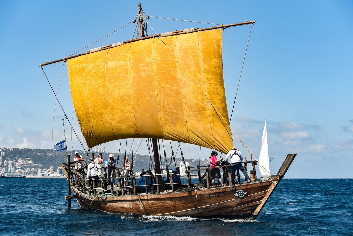
I found the replica ship, Ma’agan Mikhael II, anchored in the Shavit marina in Haifa, where the Kishon meets the Mediterranean. Early one morning, a team of about 10 volunteers, who also participated in building the replica ship, prepared the boat before it set out to sea. The crew members delicately unfurled the flax sail, which was treated with yellow ocher, flax oil and melted beeswax – traditional methods for protecting the fabric from damp and rot. They attached the heavy sail to the ship’s yard, which they raised to the top of the mast with a rope halyard.

There were already major commercial ties in the Mediterranean 3,000 years ago

With just the single sail, the ship’s navigational abilities are very limited. It set off from the marina, dwarfed by huge containers for modern merchant ships, with the aid of a tugboat. Once in open waters, the tow line with the tugboat was severed, the yard diverted to an angle of 30 degrees to the southwest wind, and Ma’agan Mikhael II sailed toward Acre at a speed of 3.4 knots (3.9 mph)

There were already major commercial ties in the Mediterranean 3,000 years ago and more, and some historians claim it was these maritime ties that enabled the development of civilizations surrounding the sea. Without the Mediterranean, ancient Greece and Rome would never have developed because there was no other way to transfer the quantities of merchandise required to maintain such large empires. Overland transport was extremely expensive and even more difficult.

Despite the importance of the maritime ties, very little is known about how sea voyages were carried out. “There are almost no written accounts on the conduct of sailings – maybe because the sailors didn’t know how to read and write,” Gal points out.

From the 13th century B.C.E. until around 700 C.E., sailors sailed in one-mast ships with a square sail like Ma’agan Mikhael II. These ships had no problem sailing from the Aegean region to the eastern Mediterranean (the Levant), with the help of the westerly winds. But they had very little ability to sail against the wind, so that it was never clear how they made the return journey.

One theory was that the sailors sailed close to the coastline, exploiting the daily breeze cycle, in order to creep northward from the Levant and to continue westward near the coast of southern Turkey. “Only when we sailed on Ma’agan Mikhael II did we understand the real limitations of the ship and the sailors,” Gal says. “We found that in many sections of the coast, the breeze doesn’t support this type of movement.”

'Over the years there are many fluctuations in temperature or in the amount of rain, but the wind regime remains almost unchanged.'

Gal found a way to solve the mystery while sailing a yacht in the Mediterranean. He noticed that although the average wind direction was westerly, there was also variance in the wind that enables sailors to occasionally take advantage of winds blowing from east to west. “The problem was that we couldn’t know whether the variance in the wind would have been enough for sailing a ship all the way from the Levant to the Aegean Sea,” he notes.

He also had to check whether it is possible to rely on modern meteorological data to represent the wind regime that prevailed in the Mediterranean some 3,000 years ago.

Gal found a study that combined all the wind listings from the period of the Greek and Roman empires. “They described the winds and their seasonality very precisely, because they were very dependent on them,” he says. Gal also used studies that examined the climatological history of the major pressure systems in the Atlantic Ocean (which then govern the wind regime in the Mediterranean), with the help of plankton residue indicated sea surface temperatures.

An in-depth examination of the two sources indicated that there was almost no difference between the wind regime in the Mediterranean 3,000 years ago and of today.

“Over the years there are many fluctuations in temperature or in the amount of rain, but the wind regime remains almost unchanged,” Gal says. “That’s what makes the present study possible.”

Sailing bug

Gal spent 20 years serving as a pilot in the Israel Air Force, and after his retirement swapped his flying bug for a sailing one. Today he is also the meteorologist supporting the Israel Sailing Association and Olympic sailing team. He gathered wind data of 7,000 points in the Mediterranean region spaced 27 kilometers (nearly 17 miles) from one another, and timed at every hour for 15 years. That’s how he got slightly less than a billion sets of data. “I needed over two months just to download the wind data and data about the wave regime and ocean currents from updated meteorological databases, which use satellite collected wind data,” he recounts.

Based on the meteorological data, Gal – who also has a degree in computer sciences – carried out simulations of voyages in a virtual ship with characteristics similar to the ancient ships, on 224 different routes in the eastern and central basins of the Mediterranean. The sampling represents most of the sailing options in ancient times.

They conducted 5,479 virtual sailings on every sailing route – the equivalent of setting sail every morning on every route for 15 years – for a total of over 1.2 million virtual sailings.

Gal examined the feasibility of completing each of the journeys, taking into account the winds, height of the waves and estimated number of days for the journey. He found that the average sailor had enough opportunities to sail westward in a reasonable manner. “We were able to map the seasonal potential sailing mobility on each possible route, and for example we identified when and why a grain ship would prefer to sail to Rome via southern Anatolia.”

“They didn’t sail counter to the prevailing wind, but waited for days with a favorable wind in the opposite direction,” he declares. “We found there were such days in a large meteorological sampling. Until now, scholars didn’t examine that but used low resolution meteorological averages that erase the variance in the wind.”

Gal adds that it’s only in the past 15 years that meteorological data of sufficiently high resolution has existed in order to discover this variance.

Furthermore, Gal used machine learning to examine whether the computer could predict when it was worth going out to sea based on the prevailing conditions on the day of departure.

It was found that the software identified 75 percent of the days when it was possible to set out for a safe journey, as well as 80 percent of the days that did not lead to a safe journey. “The ancient sailors certainly knew better how to decide when to set sail and when not to,” Gal says.

“We’re starting with the assumption that the ancient seafarers were reasonable people,” he adds. “In other words, they wanted to stay alive, and didn’t want to waste their time on a trip when they would most probably have to return to port. Just as modern-day fishermen know how to read the sky, and to estimate with high probability when the sea will be stormy and when there will be a lull of several days, we assume that the ancient sailors also knew how to read the sky and to identify with high probability when it was worth their while to embark on a journey from east to west.”

Prof. Cvikel notes that the study “changes what we thought until now. The sailors felt the sea, smelled the wind, knew when it was possible to sail. That’s something that’s passed down from grandfather to father to son, and everyone learned from a very early age. That enabled them to sail on the Mediterranean all year round and to maintain commercial ties.”

Gal tested his computerized analysis in real time. “Ma’agan Mikhael II has already set sail over 80 times, and on one of the trips went to Cyprus and back,” he says. “We have data about its performance in all wind conditions and how various currents affect it, and that enables us to conduct a reliable simulation of sailing. With its help, we acquired insights into the way such a ship is operated; we had a better understanding of how four people can sail from Greece to here and back.”

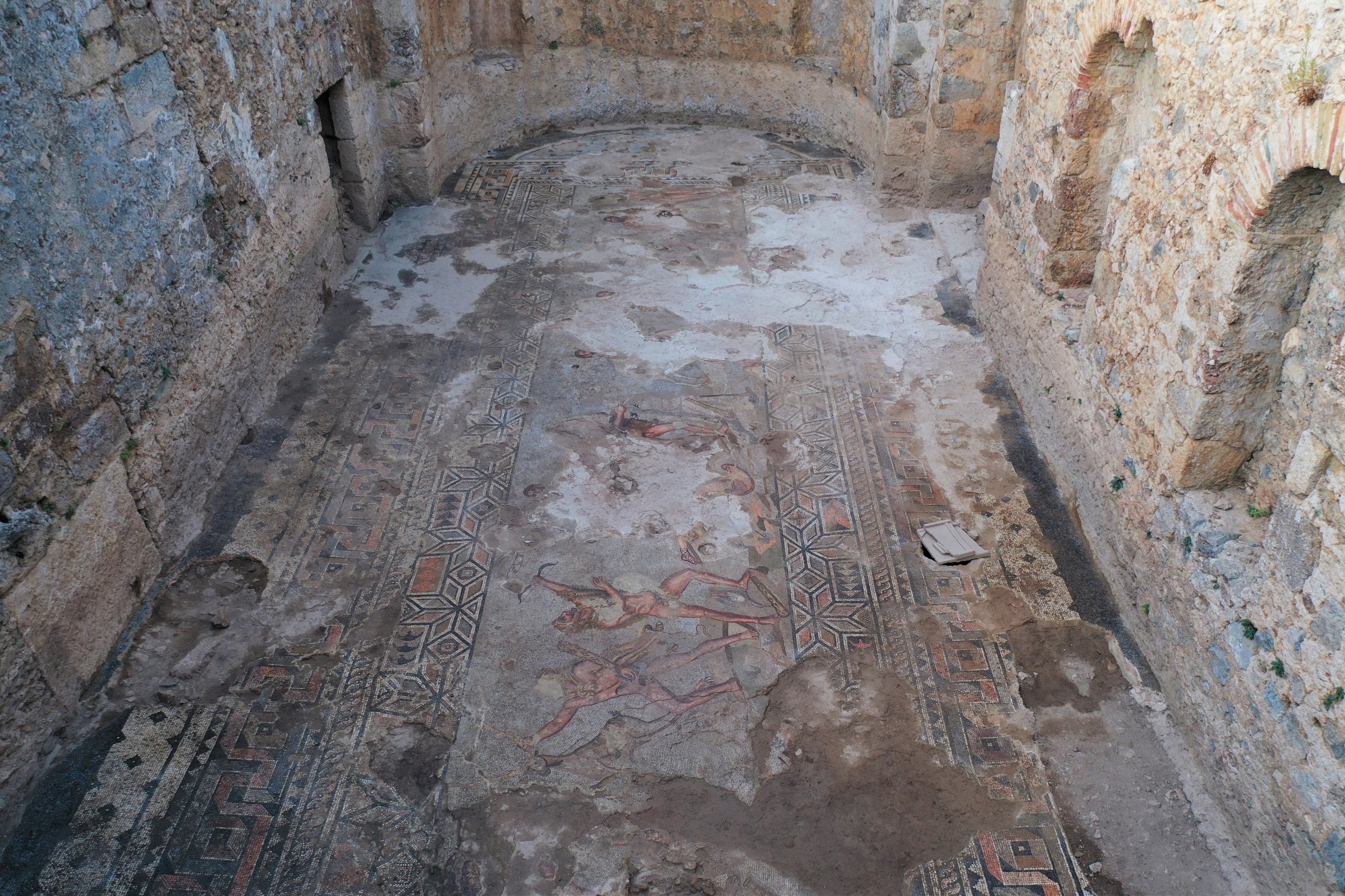
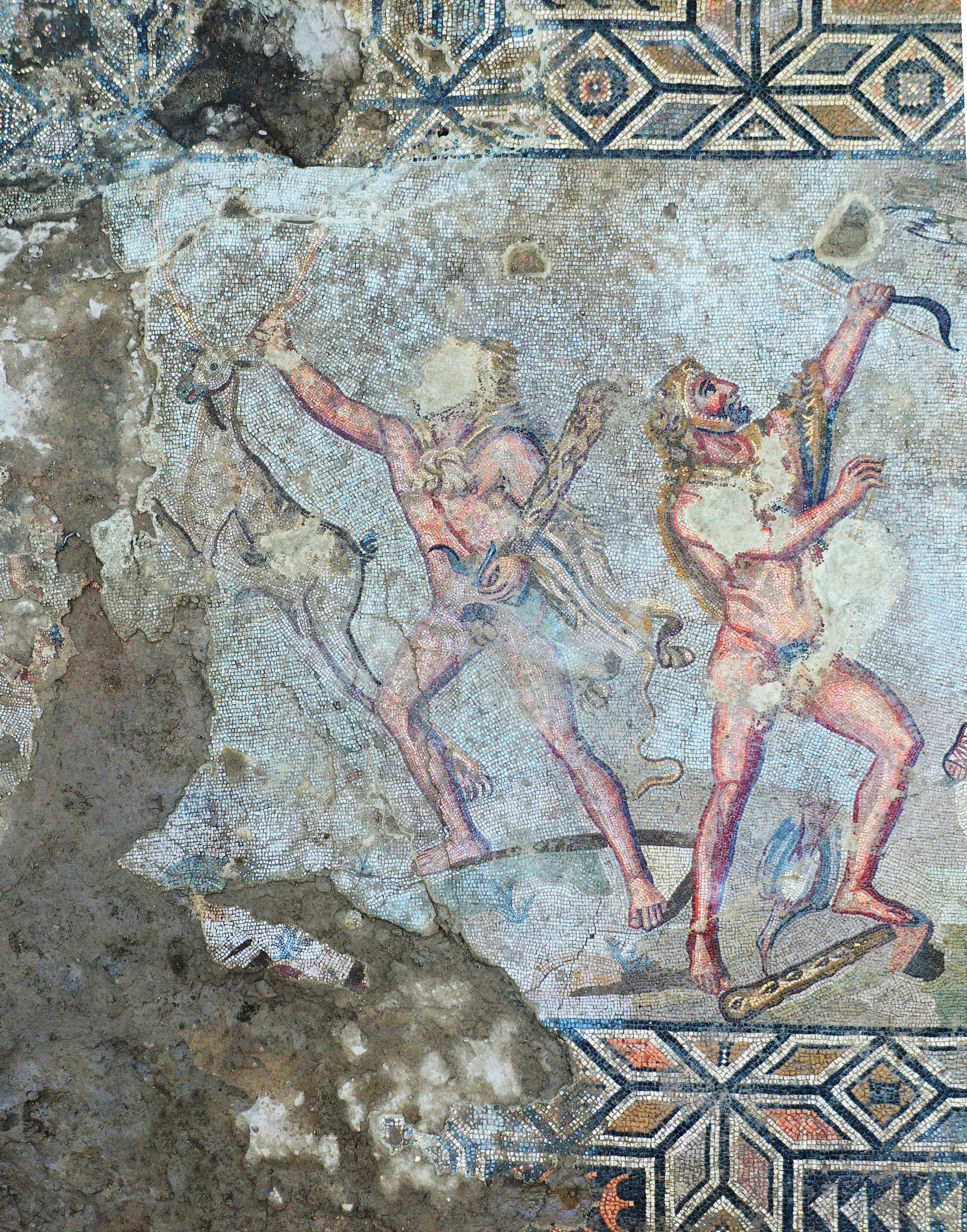
The original ship was discovered in 1985, buried at a depth of about 2 meters (6 feet, 7 inches) in the seabed near Kibbutz Ma’agan Mikhael, which was home to the ship’s researcher, Dr. Elisha Linder.

A large part of its hull was preserved, and after digging and preservation activities that lasted 15 years, researchers were able to reassemble it. The preservation of the wood alone took seven years. The original ship is now located in the Hecht Museum at the University of Haifa.

From the parts of the ship that were preserved, the researchers reconstructed a piece of its hull. In 2014, construction began on a large ship with the same dimensions, with the same materials and using the same construction methods. The work was conducted by a group of volunteers and was led by Prof. Yaacov Kahanov. Sadly, he died in 2016, a few days after the completion of the replica.

Today, Ma’agan Mikhael II is one of only two ships in the world that simulate a Mediterranean merchant sailing vessel from that period (the other is a replica of a ship that is about 100 years younger, which was found in northern Cyprus).

The original ship from Ma’agan Mikhael didn’t transport olive oil or wine, but an expensive cargo of 12 and a half tons of slate – stone that wasn’t available in the Land of Israel and was apparently meant for construction in the Greek colony of Tel Dor. The local real estate obsession is nothing new, it seems.

The theory is that the ship sank on its maiden voyage, since no remains of snails or marine flora were found on its side.

“It’s going back 2,400 years,” says Gal, reflecting about sailing on the replica. And in fact, boarding the deck of the Ma’agan Mikhael II is rather like entering a time capsule. Everything is amazingly simple. There are no electrical outlets, no plastic, no screens. The hundreds of nails that secure the planks were created manually, one at a time, from copper. And the ship sails.

“The elephant in the room in studies of seafaring is that all of the researchers are very divided regarding the capability of the ancient ships,” Gal says. “Some say they were entirely subject to the mercies of the winds, while another school claimed they were able to sail upwind, almost like modern yachts. Until now there were very hypothetical studies, and here we have a seagoing vessel with which we can really test that.”

Next spring, Gal is planning to sail the replica ship with the volunteer crew to Greece. “It will take three to four days to reach western Cyprus, where we’ll wait for another window of opportunity, and then another three to four days until Rhodes.”

A previous traveler followed a similar route. According to ancient records, Paul ended up staying in Cyprus for nearly two months.

Source: https://www.haaretz.com/science-and-health...

Thessaloniki, Greece: An Entire Underground Ancient City was found During Metro Construction

Impressive are the photos of the finds brought to light by the archaeological shovel in Thessaloniki, Greece's 2nd biggest city, during the construction of the local metro facilities.

In 2012, during the excavations carried out at the "Amaksostasio" of the main line of the Metro, in Pylaia, a pre-Cassandrian small town of the 4th century BC came to light. An area of ​​31 acres was investigated and part of the city was revealed, which was organized with the Hippodamian urban planning system, following the standards of the great cities of Macedonia, Olynthos and Pella.

The numerous finds point to a prosperous settlement with a strong economy and developed socio-political structures. Its great development is placed in the second half of the 4th century. BC, which was however interrupted by the founding of the city of Thessaloniki by Kassandros in 315 BC, when it was abandoned.

Another interesting find is the cemetery of Roman times (2nd -4th century AD) that was investigated in the limits of the Fleming Station and revealed to us aspects of a hitherto unknown settlement, on the outskirts of ancient Thessaloniki.

During the construction works of Thessaloniki METRO, at the stations near Aristoteleion University, the archaeological research revealed a large part of the eastern cemetery of the city, as well as a three-kilometer cemetery Basilica with mosaic floors on the site of an older building. In particular, it brought to light thousands of funerary monuments (3000) which have come to enrich our knowledge so far about the organization and continuous use of the space from the Hellenistic period to Late Antiquity.

The tombs belong to various types, pit-shaped, box-shaped, pot burials, altars, altar-shaped constructions, single or double vaulted, decorated with clay and glass vessels, clay figurines, gold and silver jewelry and coins.

The excavations carried out at the two stations within the historical center of Thessaloniki, the Agia Sophia Station and the Venizelos Station, complete the topographical map of the city, at the level of the main thoroughfare, today's Egnatias Street. The findings outline the urban planning organization of the urban space of Thessaloniki from its foundation to the end of late antiquity.

The city was designed in its lowland parts with the Hippodamian urban planning system. Streets, perpendicular to each other, form building islands with residential and laboratory buildings.

The same design is preserved in Roman times, with small-scale alterations to the building plan. In the 4th c. A.D. the now marble-paved streets are flanked by colonnaded arcades and on either side of them are erected large building complexes with luxurious mosaic floors, wall written decoration, marble cladding and opus sectile. At the same time, to the north of the decumanus, at the junction with the cardo of the Agia Sophia street, a cistern building/nymphaeum was constructed that shows overlapping building phases. A drastic intervention in the urban planning of the city takes place in the 6th century: the marble-paved decumanus is widened, the older buildings are leveled and in their place paved squares are formed at the central crossroads of the city.

Those imposing architectural configurations of the public space - squares, arcades and fountains/nymphaea - along the central streets are the last monumental image of late antiquity.

The excavation research in the two stations of the historical center of Thessaloniki revealed parts of the Byzantine market along the main street, the so-called Avenue or Middle of the Byzantines.

The central cobbled street of Byzantine times was revealed, in the trace of the older decumanus maximus with an average width of 5.5 to 6.5m. New roads with a straight, winding and diagonal course are drawn or existing ones change their course, simultaneously defining the extent of the building islands. The islands of mud-built buildings occupied the public space, the sidewalks and the arcades of late antiquity. These are workshops and shops of a market where jewelry, articles of metalwork, glasswork, ceramics, etc. are produced. Brick constructions, kilns, work benches, together with tools, jewelry making molds, unfinished ceramics, tripods, attest to the productive use of the premises throughout the Byzantine period.

During the Ottoman period, the urban planning changes do not seem to be radical. After all, the building remains were found disturbed by the basements of the buildings of more recent times.

The upper layer found at both stations provided evidence for the urban planning organization of Thessaloniki during the last period of the Turkish occupation (second half of the 19th century CE). marked by urban changes aimed at creating a city designed according to European standards. The buildings they excavated, mainly underground, were found destroyed by the fire of 1917 that burned down the center of Thessaloniki and was the springboard for the design of the modern city.

The stations in the west city are located in the countryside outside the old walls of Thessaloniki. The excavation research carried out in sections by periods, during the years 2009 – 2012, 2016 -2017, when it was completed, supplemented our knowledge over time from the 3rd c. BC until recent times for the spatial development of the peri-urban western zone.

The spatial organization of the area was dictated by two parameters: the passage of the main road, the well-known Roman Egnatia road that connected Thessaloniki with Pella, and the flowing streams. Overlapping gravel and earthen pavements of the road, which reached outside the Golden Gate crossing the Keramisious plain and the cemetery, were located under today's Monastiriou Street.

At the New Railway Station is a bypass and developed along the northern side of this road axis. Organized into clusters it includes a variety of tombs and altar-like structures - usually within burial enclosures, providing spaces for funerary ceremonies and offerings. Marble sarcophagi and luxurious burial buildings of the 2nd, 3rd and 4th c. AD stand out.

The period of use of the necropolis covers a long period from the 3rd century BC. up to the middle of the 4th c. AD, when Christian cemeteries are organized around cores with religious buildings, temples and martyrdoms. Later, and mainly from the 6th c. A.D. sporadic burials continue. which do not constitute an organized cemetery.

The excavation at the station and the entrances of the Democracy Square, on the outskirts of the necropolis, just a few meters outside the western walls, brought to light on either side of the road that led from the countryside to the Golden Gate, large complexes of state wine and oil warehouses (pytheon ) and laboratories of late antiquity.

On the ruins of the python, it was founded in the 5th century a square temple with a funerary addition, storerooms and workshops. At the end of the 6th c. – beginning of the 7th c. the temple and its facilities are completely destroyed and abandoned. Among its hallowed ruins are sporadic burials. Building activity is limited to the south. In the following centuries the area remained undeveloped, not by chance, after all, it was called by the Ottomans Ҫayir, i.e. Meadow or Meadow. As soon as the late 19th c. will regain its commercial character, when inns, shops and warehouses are built on the axis of Monastiriou Avenue.

Constantinople's Byzantine Basilica Cistern reopens after 5 years of Restoration Works (Photo Gallery)

The Byzantine Basilica Cistern, one of Constantinople's (Istanbul) most historical buildings, was reopened to visitors with the completion of the restoration process that started in 2017. In addition to the earthquake strengthening works, the lighting was also overhauled in the museum.

The Basilica Cistern or Cisterna of Illus (Greek kinsterne=κινστέρνη), now known as Yerebatan Saray (Turkish: underground palace) or Yerebatan Sarnıcı (Turkish: underground tank) is the largest underground water tank built in Istanbul, measuring approximately 141 × 66.5 m in plan and with a capacity of 78,000 m3. It is located on the first hill of the city, about 150 meters southwest of Hagia Sophia, in the Sultanahmet area of ​​the historic center.

The Basilica Cistern impresses visitors with its 336 columns, each 9 meters tall, and two Medusa heads. The columns are mostly cylindrical and made out of a single block. The two Medusa heads, two great examples of Roman era architecture, garners a lot of attention. Both work as the bases for two of the 336 columns located on the northwest side of the cistern. They are thought to have been brought to be used as supports for the columns at the time of construction of the cistern.

An interior view of the Basilica Cistern Museum, Istanbul, Turkey, July 22, 2022. (IHA Photo)

It was named so because of its position, below the Stoa Basilica which was west of Augustaion. The Stoa was probably built by Constantine the Great but was destroyed around 475. The cistern was shaped as it is today, when it was rebuilt around 542 by Emperor Justinian I, after the period of the Nika Riots, to supply water to Constantinople throughout the Byzantine period and to supply water to the adjacent Great Palace, where the Byzantine emperor had his seat.

It was one of Justinian's most important public works and an excellent example of Byzantine engineering. The Greek historian Procopius of Caesarea gives a detailed description of the cistern in his work ‘the Buildings’, noting that fresh water was brought into it by means of a conduit, while a quantity of water was also stored there, which was usually abundant in seasons other than summer.

After the conquest of the city by the Ottomans, knowledge of the cistern seems to have been lost, but it was later discovered by Pierre Gilles (or Petrus Gyllius, 1490 - 1555) during his tour of Constantinople in the mid-16th century. Gilles describes how the residents had no knowledge of the reservoir's existence, despite the fact that they pumped water and caught fish by throwing buckets into the basements of their houses.

A view from the light-themed exhibition at the Basilica Cistern Museum, Istanbul, Turkey, July 22, 2022. (AA Photo)

After the Fall of Constantinople, the water from the Royal Cistern was used to irrigate the gardens at the Topkapi Palace (Topkapi Sarayi). From the 18th to the middle of the 20th century, restoration works were carried out to preserve the cistern, which, after a renovation that began in 1985, had been open to the general public since 1987 and is one of the most important and oldest public spaces. Musical concerts are given in its space with excellent acoustics.

photos by AFP/IHA/AA

As part of the restoration, launched in 2017, the ties fixing the columns to each other were renewed to prepare the construction for a possible earthquake. The entrance hall of the cistern was also redesigned while the lighting was renovated. The cistern now hosts visitors with an exhibition themed "light."

The Basilica Cistern Museum can be visited between 9 a.m. and 5 p.m.